This project is the final
phase of a watershed restoration effort initiated in 2000. The original goal of the Alamosa River
Watershed Restoration Project was to stabilize the river to reduce sediment
loading, limit bank erosion, restore riparian habitat, stabilize the water
table along the riparian corridor and reduce continued down cutting and
instability of the river channel as well as decrease damage to irrigation head
gates, roads and bridges. A secondary
goal has been the development of Best Management Practices (BMPs) to improve
the stream and the surrounding riparian area.
Benefits will include sediment reduction with achievements documented through post-construction monitoring. The riverbank and bed stability will be improved by the installation of meander pattern, normal geomorphologic cross section geometry, floodplain connection and function enhancements. The re-growth of the natural riparian corridor habitat, the re-appearance of native species such as willows, narrow leaf cottonwood, american alder, and the anticipated increase in migratory and native birds are additional successes to be tracked. The proposed measures will improve water quality and the amount of water available for public and agricultural use and for wildlife and aquatic habitat. In addition to the importance of a stable riparian ecosystem, the quality and availability of water from the Alamosa River is vital to the sustainability and future of the greater Capulin community and the surrounding agricultural region.
Benefits will include sediment reduction with achievements documented through post-construction monitoring. The riverbank and bed stability will be improved by the installation of meander pattern, normal geomorphologic cross section geometry, floodplain connection and function enhancements. The re-growth of the natural riparian corridor habitat, the re-appearance of native species such as willows, narrow leaf cottonwood, american alder, and the anticipated increase in migratory and native birds are additional successes to be tracked. The proposed measures will improve water quality and the amount of water available for public and agricultural use and for wildlife and aquatic habitat. In addition to the importance of a stable riparian ecosystem, the quality and availability of water from the Alamosa River is vital to the sustainability and future of the greater Capulin community and the surrounding agricultural region.
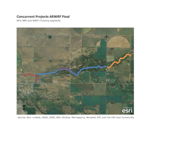
Phase III of the restoration project will continue the work completed in the previous two phases. The Alamosa River Watershed Restoration Foundation, Inc., seeks to complete the restoration of the remaining 14,200 feet of channel which, when completed and meanders constructed, will create an additional 15,000 feet of restored and stabilized river system. Phase III of restoration will be split into 2 projects: From County Road 8 to the Capulin Ditch (roughly 1,500 ft), there is urgent need to address flooding potential because deposition behind the irrigation diversion structure at the Capulin Ditch has raised the stream channel and the bridge at County Road 8 needs to be improved. This project will require participation from the County and the Capulin Ditch Company. Funding for this stream segment will be from the NRD funds in combination with participation from the many stakeholders involved.
From the Capulin Ditch to below County Road 9, river restoration is a 60% EPA Non-Point Source grant matched 40% by the ARWRF, landowners and other in-kind and volunteer efforts, as well as some cash sources. This segment of the project is currently underway, with Black Creek Hydrology as the designer, the Porco Quarry as the rock source and the Capulin Construction Company as the in-stream construction contractor. The design is currently being finalized and updated. Rock stockpiles and equipment staging will begin as soon as access improves. Construction will begin in late February-early March depending on frost conditions.
The remaining stream restoration to County Road 10 (approximately 5,000 ft of stream) will be completed in a project using funds from the NRD settlement established after the Summitville Mine Superfund Site legal action. ARWRF is currently in Phase I/II of a 3 phase process, with an RFQ/RFP from River Restoration Design Firms who can complete a PE approved design for the remaining stream.

The NPS project continues the design prepared and implemented in the 2004 effort, which will be field verified and modified based on changes that have occurred since the original design was completed. The design includes reshaping portions of the channel to a natural meander riffle/ pool sequence, reconnecting the flood plain to the river channel, and installing rock structures to direct the flow away from the banks and provide bed grade control. Replacing the vegetative cover and improving the grazing practices along the river will further stabilize the banks. The restoration design that will be implemented uses a fluvial geomorphic type approach of river construction. Restoration is achieved by creating correct width to depth ratios, reestablishing the meander bends, and reconnecting the flood plain to the river channel. This portion of the project will be funded 60% by NPS funds (managed by CDPHE Water Quality Division) and 40% by landowner and community in-kind/cash. The goals of the project include erosion control BMP's, Riparian Management BMP's and sustainability through local partnerships that create long term stewardship of the project.
The NRD project is being conducted in 3 stages. Stage 1 is currently underway, and involves hiring a qualified person to act as project managers for the ARWRF, securing landowner access and agreement and developing an RFQ for a design firm. Stage 2 of the NRD project will involve selecting a design firm for the project capable of conducting required hydraulic and other analyses, a review of past projects and completion of a P.E. stamped design for final implementation. The Design firm will complete bid documents that can then be put out to bid for the in-stream construction contractor. Stage 3 of this project will be the selection of the in-stream contractor and construction.
Project History:
In 1997, Dave Rosgen completed an assessment
and conceptual plan for the reach from Terrace Reservoir to Hwy. 285, and in
2001, the team of Black Creek Hydrology, Williams and Associates and Western
Hydrology began and subsequently completed a detailed design for the 5.4 mile
reach.
Using a “fluvial geomorphologic approach,” the proposed work will
reduce sediment introduction into the river system by breaking the negative
feedback loop caused by erosion and the ensuing sediment movement as bank forms
degrade and/or accumulate sediment. The design for the project was completed in
2003. Half of the project construction
(2.65 miles, Phase I and Phase II) was completed between the years of 2004 and
2005.
Significant progress to
restore the banks has been made by the Alamosa La Jara Water Conservancy
District and the Alamosa River Watershed Restoration Foundation through the
Colorado Nonpoint Source program funding, Colorado Water Conservation Board
funding, and local in-kind and cash match totaling over $1,000,000.00.
Extensive work was completed in 2004 on 7,000 feet of channel below the
Gunbarrel Road. An additional 7,000 feet of channel was treated in 2005 to
County Road 8. The work included removal
of excess sediment, reestablishment of natural meander patterns, installation
of rock vanes, riparian vegetation replanting and grazing management. These
measures have had demonstrable success and need to be continued on the
remainder of the untreated channel.
 |
| Add caption |